Shwethaungyan Subtownship
ရွှေသောင်ယံမြို့နယ်ခွဲ Shwe Thaung Yan Subtownship | |
|---|---|
Subtownship | |
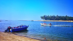
 View of Chaungtha Island from Chaungtha Beach | |
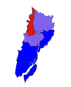
 Location in Pathein district | |
| Coordinates: 17°5′N 94°30′E / 17.083°N 94.500°E | |
| Country | |
| Region | Ayeyawady Region |
| District | Pathein District |
| Township | Pathein Township |
| Area | |
| • Total | 178.5 sq mi (462.3 km2) |
| Population (2014)[1] | 49,538 |
| Time zone | UTC+6:30 (MST) |
Shwethaungyan Subtownship (Burmese: ရွှေသောင်ယံမြို့နယ်ခွဲ [ʃwè.ð̆àʊɰ̃.jàɰ̃ mjo̼.nɛ̀.kʰu̯ɛ́]), also spaced out as Shwe Thaung Yan, is a subtownship in Pathein District, Ayeyarwady Region, Myanmar. The subtownship is split between Pathein Township and Thabaung Township; it has a total area of 178.50 square miles (462.3 km2),[1] with 153.16 square miles (396.7 km2) in Pathein and 25.34 square miles (65.6 km2) in Thabaung.[2]
- ^ a b "The 2014 Myanmar Population and Housing Census: Shwe Thaung Yan Township Report". Open Development Cambodia (in Burmese). Open Development Myanmar. May 2017.
- ^ Myanmar Information Management Unit (September 2019). Pathein Myone Daethasaingyarachatlatmya ပုသိမ်မြို့နယ် ဒေသဆိုင်ရာအချက်လက်များ [Pathein Township Regional Information] (PDF) (Report). MIMU. Retrieved October 24, 2022.