| Sierra de Aracena | |
|---|---|
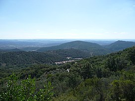
 Landscape of Sierra de Aracena with the ubiquitous small village in the valley | |
| Highest point | |
| Peak | Cerro del Castaño |
| Elevation | 962 m (3,156 ft) |
| Coordinates | 33°57′35″N 6°35′7″W / 33.95972°N 6.58528°W |
| Dimensions | |
| Length | 58 km (36 mi) NW/SE |
| Width | 15 km (9.3 mi) NE/SW |
| Geography | |
| Location | Andalusia |
| Country | Spain |
| Range coordinates | 37°54′N 6°37′W / 37.900°N 6.617°W |
| Parent range | Sierra Morena |
| Geology | |
| Orogeny | Variscan orogeny |
| Rock age | Paleozoic |
| Rock type(s) | Schist, slate and quartzite |
Sierra de Aracena is the westernmost mountain range of the Sierra Morena, Andalusia, Spain. It is located in the northern part of Huelva Province.
The range is named after the town of Aracena.
