| Sierra de los Tuxtlas | |
|---|---|
 Cloud-shrouded San Martin Tuxtla | |
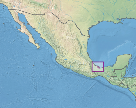
 Location of the Sierra de los Tuxtlas | |
| Ecology | |
| Realm | Neotropical |
| Biome | Tropical and subtropical moist broadleaf forests |
| Borders | Petén–Veracruz moist forests |
| Geography | |
| Area | 3,813 km2 (1,472 sq mi) |
| Country | Mexico |
| States | Veracruz |
| Coordinates | 18°27′N 94°57′W / 18.450°N 94.950°W |
| Conservation | |
| Conservation status | Critical/endangered |
| Protected | 1,519 km² (40%)[1] |
The Sierra de Los Tuxtlas (Tuxtlas Mountains) are a volcanic belt and mountain range along the southeastern Veracruz Gulf coast in Eastern Mexico. The Los Tuxtlas Biosphere Reserve (Biósfera Los Tuxtlas) includes the coastal and higher elevations of the Sierra de Los Tuxtlas.
The volcanic mountains were used as a basalt source by the Olmec culture during the Early Formative period (c. 1500 BCE – c. 400 BCE). Quarried basalt was transported by raft through a network of rivers, to sites in the Olmec heartland for use in creating monuments, including colossal heads.[2]
- ^ Dinerstein, Eric; Olson, David; et al. (June 2017). "An Ecoregion-Based Approach to Protecting Half the Terrestrial Realm". BioScience. 67 (6): 534–545. doi:10.1093/biosci/bix014. PMC 5451287. PMID 28608869.
{{cite journal}}: CS1 maint: date and year (link) Supplemental material 2 table S1b. - ^ Ancient Mexico and Central America