Siksa
سکسا | |
|---|---|
Village | |
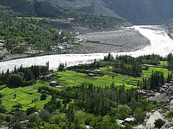
 Shyok River passing Siksa | |
| Coordinates: 34°55′48″N 76°36′57″E / 34.93000°N 76.61583°E | |
| Country | Pakistan |
| Autonomous territory | |
| District | Ghanche |
| Subdivision | Chorbat |
| Time zone | UTC+5 (PST) |
| • Summer (DST) | UTC+6 (GMT+5) |
| Website | https://swa.org.pk |
Siksa is a village in the sub division Chorbat Valley, Ghanche District of Gilgit-Baltistan, lying 150 kilometres (93 mi) east of Skardu, near the border of Pakistan and India at an elevation of 2,725 metres (8,940 ft).
In historical travel writings Siksa is referred to as the "Chorbat village". It is also described as the principal village of the Chorbat ilaqa, where the officials of Chorbat lived.[1] Siksa is at the end of the Chorbat Lungpa valley, which leads to the Chorbat La pass, the historical route between Baltistan and Ladakh.[2]
The language spoken is Balti. The entire population is Muslim of the Sofia Noorbakhshia and Ahl-i-Hadith or Ahl-e-Hadith (Urdu: اہلِ حدیث, people of hadith) sects.
- ^ Gazetteer of Kashmir and Ladak (1890), p. 750.
- ^ Drew, The Jummoo and Kashmir Territories (1875): "The Chorbat Pass is the boundary of Baltistan in this direction; by this road also used to come Balti raiders, as the remains of a fort at Yogma Hanū prove, which the people of the valley had put up against them."
