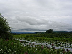
Silver Lake, Washington | |
|---|---|
 Silver Lake, 2017 | |
| Coordinates: 46°17′50″N 122°48′38″W / 46.29722°N 122.81056°W | |
| Country | United States |
| State | Washington |
| County | Cowlitz |
| Elevation | 158 m (518 ft) |
| Time zone | UTC−8 (PST) |
| • Summer (DST) | UTC−7 (PDT) |
| ZIP code | 98645 |
| Area code | 360 |
| FIPS code | 53-64400 |
| GNIS feature ID | 1508354 |

Silver Lake, sometimes Silverlake, is an unincorporated community in Cowlitz County, Washington, in the southwestern portion of the state. Silver Lake is located 6 miles (9.7 km) east of Castle Rock along Washington State Route 504, which is also known as the Spirit Lake Memorial Highway.[2] The area considered Silverlake is about 6 miles (10 km) east of Interstate 5 (I-5) and is approximately 50 miles (80 km) from Portland, Oregon, to the south and Seattle about 110 miles (180 km) to the north. The closest cities to the subject property are Castle Rock, six miles (10 km) to the west, and Toutle, four miles (6 km) east.
The Silver Lake community takes its name from the lake of the same name, which it lies on the northwest shore of. The Silver Lake community is part of the Toutle Lake School District, a K-12 school district of about 600 students. Silver Lake is about 30 miles (48 km) west of Mount St. Helens and near the Mount St. Helens National Volcanic Monument, which lies at the end of the Spirit Lake Memorial Highway. The eruption of Mount St. Helens on May 18, 1980 was the deadliest and most economically destructive volcanic event in the history of the United States. The WDFW has planted grass carp in this lake. The grass carp have lived far longer than expected, and have destroyed much of the beneficial native vegetation. It is now legal to fish for or retain grass carp.[3]
Silverlake also describes the associated marsh. It is home to a nature trail, and the visitor center for the Mount St. Helens National Volcanic Monument.
- ^ "USGS—Silver Lake, Washington". Retrieved June 12, 2014.
- ^ Washington State Legislature. "RCW 47.17.655: State Route 504". Retrieved June 12, 2014.
- ^ "Lowland lakes | Washington Department of Fish & Wildlife".

