| Simplon Pass | |
|---|---|
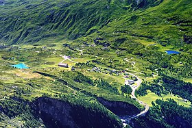
 View of the Simplon Pass from above with the Rotelsee (left) and Lake Hopschu (right). Note the slightly lower marshland behind the road. | |
| Elevation | 2,006 m (6,581 ft)[1] |
| Traversed by | Road |
| Location | Valais, Switzerland |
| Range | Alps |
| Coordinates | 46°15′6″N 8°2′0″E / 46.25167°N 8.03333°E |
The Simplon Pass (French: Col du Simplon; German: Simplonpass; Italian: Passo del Sempione; Lombard: Pass del Sempion; 2,006 m or 6,581 ft; Romansh: Pass dal Simplon) is a high mountain pass between the Pennine Alps and the Lepontine Alps in Switzerland. It connects Brig in the canton of Valais with Domodossola in Piedmont (Italy). The pass itself and the villages on each side of it, such as Gondo, are in Switzerland. The Simplon Tunnel was built beneath the vicinity of the pass in the early 20th century to carry rail traffic between the two countries.
The lowest point of the col, and the lowest point on the watershed between the basins of the Rhone and the Po in Switzerland lies in marshland about 500 m (1,640 ft) west of the Simplon Pass settlement at an altitude of 1,995 m or 6,545 ft.[2]
Rotelsee is a lake located near the pass at an elevation of 2,028 m (6,654 ft).
There are several high peaks around that can be climbed directly from the pass. These include Wasenhorn, Hubschhorn, Breithorn (Simplon), and Monte Leone.
- ^ Retrieved from the Swisstopo topographic map (1:25'000)
- ^ Finsteraarhorn peakbagger.com
