| Simpson Bay Lagoon | |
|---|---|
| Simson Bay Lagoon The Great Pond | |
 | |
| Coordinates | 18°03′07″N 63°06′32″W / 18.052°N 63.109°W |
| Primary outflows | Baie Nettlé Simson Bay |
| Ocean/sea sources | Caribbean sea |
| Basin countries | Saint Martin Sint Maarten |
| Designation | |
| Official name | Mullet Pond |
| Designated | 23 May 2014 |
| Reference no. | 2270[1] |
| Surface area | 1,250 hectares (3,100 acres) |
| Max. depth | 6 metres (20 ft) |
| Shore length1 | 4.48 kilometres (2.78 mi) |
| Islands | Grand îlet Little Key |
| 1 Shore length is not a well-defined measure. | |

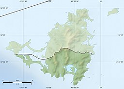
Simpson Bay Lagoon (also spelt Simson Bay Lagoon, or referred to simply as The Great Pond) is one of the largest inland lagoons in the West Indies of the Caribbean. It is located on the island of Saint Martin. The border between the French and Dutch halves of the island runs across the centre of the lagoon. There are two small islands that lie in the lagoon: the larger, Grand Ilet (also known as Explorer's Island) to the north, is within the French region of Saint-Martin; the smaller, Little Key, to the south, is on the Dutch Sint Maarten side.
The lagoon is connected to the Caribbean Sea via a small channel in the north-west which flows into Baie Nettlé in Saint-Martin and another small channel in the south-east which flows into Simson Bay in Sint Maarten. Sint Maarten's airport, Princess Juliana International Airport lies close to the lagoon's southern shore.
- ^ "Mullet Pond". Ramsar Sites Information Service. Retrieved 25 April 2018.

