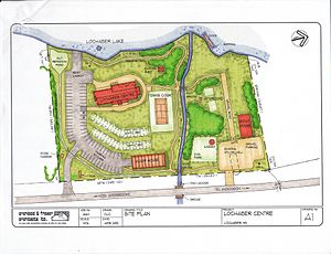

A site plan or a plot plan is a type of drawing used by architects, landscape architects, urban planners, and engineers which shows existing and proposed conditions for a given area, typically a parcel of land which is to be modified. Sites plan typically show buildings, roads, sidewalks and paths/trails, parking, drainage facilities, sanitary sewer lines, water lines, lighting, and landscaping and garden elements.[1]
Such a plan of a site is a "graphic representation of the arrangement of buildings, parking, drives, landscaping and any other structure that is part of a development project".[2]
A site plan is a "set of construction drawings that a builder or contractor uses to make improvements to a property. Counties can use the site plan to verify that development codes are being met and as a historical resource. Site plans are often prepared by a design consultant who must be either a licensed engineer, architect, landscape architect or land surveyor".[3]
Site plans include site analysis, building elements, and planning of various types including transportation and urban. An example of a site plan is the plan for Indianapolis[4] by Alexander Ralston in 1821.
The specific objects and relations shown are dependent on the purpose for creating the plot plan, but typically contain: retained and proposed buildings, landscape elements, above-ground features and obstructions, major infrastructure routes, and critical legal considerations such as property boundaries, setbacks, and rights of way…
- ^ "Department of Building and Development Land Development". Loudoun County Government. Archived from the original on May 27, 2010. Retrieved 11 Feb 2009.
- ^ Frequently Asked Questions Archived 2020-04-18 at the Wayback MachineMiami Township. Accessed 11 Feb 2009.
- ^ Site Planning Process Chesterfield County, Virginia Planning Department. Accessed 11 Feb 2009. Archived March 29, 2009, at the Wayback Machine
- ^ "Alexander Ralston's 1821 Plan for Indianapolis | The Cultural Landscape Foundation". tclf.org. Retrieved 2020-04-28.