| Siuslaw jetties | |
|---|---|
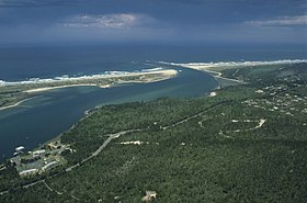
 Aerial view of Siuslaw River and jetties | |
 Click on the map for a fullscreen view | |
| Location | |
| Country | |
| Location | Florence, Oregon |
| Coordinates | 44°01′03″N 124°08′20″W / 44.0174°N 124.1390°W |
| UN/LOCODE | USFQE |
| Details | |
| Opened | 1917 |
| Type of harbour | Coastal Breakwater |
| North jetty | 6,200 feet (1,900 m) |
| South jetty | 6,500 feet (2,000 m) |
| Channel depth | 18 feet (5.5 m) |


The Siuslaw jetties (/saɪˈjuːslɔː/ sy-YOO-slaw)[1] at Florence, Oregon, in the United States, are parallel rubble-mound structures at the entrance of the Siuslaw River, bounding the north and south banks and protecting the navigation channel. The jetties extend into the Pacific Ocean, with spur jetties designed to reduce breakers and shoaling across the sand bar.
The U.S. Army Corps of Engineers (USACE) completed the jetties in 1917, and completed reconstruction and lengthening projects in 1962. USACE lengthened the jetties again in 1985, and spur jetties were added at that time to reduce the need for annual dredging.
- ^ "Frequently Asked Questions". United States Forest Service. Retrieved May 12, 2020.