Slocan | |
|---|---|
| Village of Slocan[1] | |
 | |
Location of Slocan in British Columbia | |
| Coordinates: 49°45′58″N 117°28′6″W / 49.76611°N 117.46833°W | |
| Country | Canada |
| Province | British Columbia |
| Region | Slocan Valley, West Kootenay |
| Regional district | Central Kootenay |
| Incorporated | 1901 then 1958 |
| Government | |
| • Governing body | Slocan Village Council |
| • Mayor | Jessica Lunn |
| Area | |
| • Total | 0.78 km2 (0.30 sq mi) |
| Elevation | 450 m (1,480 ft) |
| Population (2021) | |
| • Total | 379 |
| • Density | 381.7/km2 (989/sq mi) |
| Time zone | UTC-8 (PST) |
| Area codes | 250, 778, 236, & 672 |
| Highways | |
| Waterways | Slocan Lake, Slocan River |
| Website | Official website |
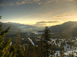
The Village of Slocan is in the West Kootenay region of southeastern British Columbia. The former steamboat landing and ferry terminal is at the mouth of Springer Creek, at the foot of Slocan Lake.[2][3] The locality, on BC Highway 6 is about 69 kilometres (43 mi) by road north of Castlegar and 183 kilometres (114 mi) by road and ferry south of Revelstoke.
- ^ "British Columbia Regional Districts, Municipalities, Corporate Name, Date of Incorporation and Postal Address" (XLS). British Columbia Ministry of Communities, Sport and Cultural Development. Retrieved 2 November 2014.
- ^ "Slocan (village)". BC Geographical Names.
- ^ "Springer Creek (creek)". BC Geographical Names.
