| Sneinton | |
|---|---|
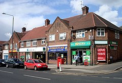
 Sneinton Dale, the area's high street | |
Location within Nottinghamshire | |
| Population | 12,689 (2011)[1] |
| OS grid reference | SK 58848 39685 |
| Unitary authority | |
| Shire county | |
| Region | |
| Country | England |
| Sovereign state | United Kingdom |
| Post town | NOTTINGHAM |
| Postcode district | NG2 |
| Dialling code | 0115 |
| Police | Nottinghamshire |
| Fire | Nottinghamshire |
| Ambulance | East Midlands |
| UK Parliament | |

Sneinton (pronounced "Snenton") is a suburb of Nottingham and former civil parish in the Nottingham district, in the ceremonial county of Nottinghamshire, England. The area is bounded by Nottingham city centre to the west, Bakersfield to the north, Colwick to the east, and the River Trent to the south. Sneinton lies within the unitary authority of Nottingham City, having been part of the borough of Nottingham since 1877.
Sneinton existed as a village since at least 1086, but remained relatively unchanged until the industrial era, when the population dramatically expanded. Further social change in the post-war period left Sneinton with a multicultural character. Sneinton residents of note include William Booth, founder of The Salvation Army, and mathematician George Green, who worked Green's Mill at the top of Belvoir Hill.
In modern times, regeneration has seen most of the old telephone exchange converted into student accommodation, the market place replaced by a pedestrian plaza and the wholesale fruit and fish market units in the traditional avenue layout re-used for artisan small businesses.[2][3][4]
- ^ Cite error: The named reference
censuswas invoked but never defined (see the help page). - ^ Controversial student accommodation extension approved, despite multiple objectionsNottinghamshire Live, 24 September 2020. Retrieved 10 November 2022
- ^ Sneinton businesses face worry over plans to demolish buildings for student flats Nottinghamshire Live, 22 April 2022. Retrieved 10 November 2022
- ^ Our history Sneinton Market Avenues. Retrieved 10 November 2022
