So Kon Po
掃桿埔 | |
|---|---|
Suburb | |
 Entrance to Hong Kong Stadium at Eastern Hospital Road. | |
 | |
| Coordinates: 22°16′27″N 114°11′22″E / 22.27414°N 114.18937°E | |
| Country | China |
| SAR | |
| District | Wan Chai District |
| So Kon Po | |
|---|---|
| Traditional Chinese | 掃桿埔 |
| Simplified Chinese | 扫杆埔 |
| Cantonese Yale | Sou gon bou |
| Hanyu Pinyin | Sǎogǎnpǔ |
| Yale Romanization | Sou gon bou |
| Jyutping | Sou3 gon1 bou3 |


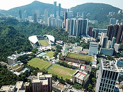
So Kon Po or Sookunpo (Chinese: 掃桿埔) is an area of Hong Kong Island located south of Causeway Bay and Victoria Park in Hong Kong. It neighbours Caroline Hill and Jardine's Lookout.[1]
- ^ "So Kon Po". GeoInfo Map. Lands Department. Retrieved 8 January 2019.