| Socompa | |
|---|---|
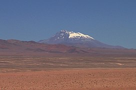
 Socompa as seen from near the Salar de Imilac | |
| Highest point | |
| Elevation | 6,051 m (19,852 ft)[1] |
| Prominence | 2,015 m (6,611 ft)[1] |
| Parent peak | Ojos del Salado |
| Listing | Ultra |
| Coordinates | 24°23′45.24″S 068°14′45.59″W / 24.3959000°S 68.2459972°W |
| Geography | |
| Location | Argentina – Chile |
| Parent range | Andes |
| Geology | |
| Mountain type | Stratovolcano |
| Last eruption | 5,910 ± 430 years ago[2] |
Socompa is a large stratovolcano (composite volcano) on the border of Argentina and Chile. It has an elevation of 6,051 metres (19,852 ft) and is part of the Chilean and Argentine Andean Volcanic Belt (AVB). Socompa is within the Central Volcanic Zone, one of the segments of the AVB which contains about 44 active volcanoes. It begins in Peru and runs first through Bolivia and Chile, and then Argentina and Chile. Socompa lies close to the pass of the same name where the Salta-Antofagasta railway crosses the Chilian border.
Most of the northwestern slope of Socompa collapsed catastrophically 7,200 years ago to form an extensive debris avalanche deposit. The Socompa collapse is among the largest known on land with a volume of 19.2 cubic kilometres (4.6 cu mi) and covers a surface area of 490 square kilometres (190 sq mi), and its features are well-preserved by the arid climate. The deposit was at first considered to be either a moraine or a pyroclastic flow deposit, until the 1980 eruption of Mount St. Helens prompted awareness of the instability of volcanic edifices and the existence of large-scale collapses. There are large toreva blocks, which were left behind within the collapse crater. After the landslide, the volcano was rebuilt by the effusion of lava flows and much of the scar is now filled in.
Socompa is also noteworthy for the high-altitude biotic communities that are bound to fumaroles on the mountain. They are well above the sparse regular vegetation in the region, which does not extend up the mountains. The climate on the mountain is cold and dry.
- ^ a b "Argentina and Chile North Ultra-Prominences" Peaklist.org. Retrieved 25 February 2013.
- ^ Grosse et al. 2022, p. 4.
