| Soke of Peterborough | |||||||
|---|---|---|---|---|---|---|---|
| 1889–1965 | |||||||
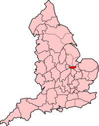
 Soke of Peterborough shown within England, with 1890 borders | |||||||
| Capital | Peterborough | ||||||
| Area | |||||||
• 1901 | 216.37 km2 (83.54 sq mi) | ||||||
• 1961 | 216.37 km2 (83.54 sq mi) | ||||||
| Population | |||||||
• 1901 | 41,122 | ||||||
• 1961 | 74,758 | ||||||
| Status | Administrative county of the United Kingdom | ||||||
| Government | Soke of Peterborough County Council | ||||||
| • Motto | Cor Unum (One Heart) | ||||||
| History | |||||||
• Established | 1889 | ||||||
• Disestablished | 1965 | ||||||
| |||||||
The Soke of Peterborough was a historic area of England associated with the City and Diocese of Peterborough. It was part of Northamptonshire, but was administered by its own county council, while the rest of Northamptonshire was administered by Northamptonshire County Council. The Soke was also described as the Liberty of Peterborough, or as the Nassaburgh hundred, and comprised, besides Peterborough, about thirty parishes.[1] The Soke was abolished in 1965.
The area formed much of the present City of Peterborough unitary authority area in the post-1974 ceremonial county of Cambridgeshire. The Church of England dioceses of Peterborough and Ely still, however, follow the boundary of the Soke, with only the part of the city that is north of the River Nene lying within the Diocese of Peterborough,[2][3] while urban areas south of the Nene, including Stanground and Fletton, are in the Diocese of Ely.
The term soke refers to a general legal term in medieval England referring to various concepts, including a jurisdiction of land or rights to hold a court or receive fines.
- ^ Britton, John and Brayley, Edward Wedlake The Beauties of England and Wales J. Harris, London, 1818
- ^ Background information Archived 16 May 2008 at the Wayback Machine Diocese of Peterborough (Retrieved 2 May 2009)
- ^ "Bishop Donald becomes Assistant Bishop in the Diocese of Ely". Diocese of Peterborough. Retrieved 1 June 2018.
