This article needs additional citations for verification. (July 2021) |
Soledad, California | |
|---|---|
| City of Soledad | |
|
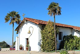
Clockwise: Mission Nuestra Señora de la Soledad; Soledad High School; Mission Soledad. | |
 Location in Monterey County and the state of California | |
| Coordinates: 36°25′29″N 121°19′35″W / 36.42472°N 121.32639°W | |
| Country | United States |
| State | California |
| County | Monterey |
| Incorporated | March 9, 1921[1] |
| Government | |
| • Mayor | Anna Velasquez [2] |
| • State senator | Shannon Grove (R)[3] |
| • Assemblymember | Dawn Addis (D)[3] |
| • U. S. rep. | Zoe Lofgren (D)[4] |
| Area | |
| • Total | 4.65 sq mi (12.0 km2) |
| • Land | 4.46 sq mi (11.6 km2) |
| • Water | 0.19 sq mi (0.5 km2) 4.09% |
| Elevation | 190 ft (58 m) |
| Population | |
| • Total | 24,925 |
| • Density | 5,588.6/sq mi (2,157.8/km2) |
| Time zone | UTC-8 (Pacific) |
| • Summer (DST) | UTC-7 (PDT) |
| ZIP code | 93960 |
| Area code | 831 |
| FIPS code | 06-72520 |
| Website | cityofsoledad |
Soledad is a city in Monterey County, California, United States. It is in the Salinas Valley, 21 miles (34 km) southeast of Salinas, the county seat.[6][8] Soledad's population was 24,925 at the 2020 census,[7] down from 25,738 in 2010. Soledad's origins started with Mission Nuestra Señora de la Soledad, founded by the Spanish in 1791, under the leadership of Fermín de Lasuén. Catalina Munrás began developing the town of Soledad on her Rancho San Vicente in the 1860s, which eventually incorporated as a city in 1921. Today, Soledad is a notable tourist destination, owing to the heavily restored mission, its proximity to Pinnacles National Park, and its numerous vineyards, as part of the Monterey wine region.
- ^ "California Cities by Incorporation Date". California Association of Local Agency Formation Commissions. Archived from the original (Word) on November 3, 2014. Retrieved August 25, 2014.
- ^ "City Council". City of Soledad. Retrieved March 15, 2015.
- ^ a b "Statewide Database". UC Regents. Archived from the original on February 1, 2015. Retrieved December 8, 2014.
- ^ "California's 18th Congressional District - Representatives & District Map". Civic Impulse, LLC. Retrieved September 24, 2014.
- ^ "2022 U.S. Gazetteer Files: California". United States Census Bureau. Retrieved November 14, 2022.
- ^ a b "Soledad". Geographic Names Information System. United States Geological Survey, United States Department of the Interior. Retrieved March 15, 2015.
- ^ a b "P1. Race – Soledad city, California: 2020 DEC Redistricting Data (PL 94-171)". U.S. Census Bureau. Retrieved November 14, 2022.
- ^ Durham, David L. (1998). California's Geographic Names: A Gazetteer of Historic and Modern Names of the State. Clovis, Calif.: Word Dancer Press. p. 961. ISBN 1-884995-14-4.


