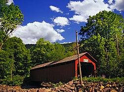
Sonestown Covered Bridge | |
|---|---|
 The Sonestown Covered Bridge over Muncy Creek (west portal and north side in 2008) | |
| Coordinates | 41°20′47″N 76°33′18″W / 41.34639°N 76.55500°W[1][2] |
| Carries | TR 310 |
| Crosses | Muncy Creek |
| Locale | Sullivan County, Pennsylvania |
| Official name | Sonestown Covered Bridge |
| Other name(s) | Davidson Covered Bridge |
| Named for | Village of Sonestown |
| Maintained by | Sullivan County |
| NBI Number | 000000000032095[2] |
| Characteristics | |
| Design | National Register of Historic Places |
| Total length | 110 ft (34 m)[2] |
| Width | 15.0 ft (4.6 m)[3] |
| Height | 10.0 ft (3.0 m) |
| Load limit | 3 tons (2.7 t) |
| History | |
| Built | c. 1850 |
| Rebuilt | 1969, 1996, 2001, 2005, 2013 |
| MPS | Covered Bridges of Bradford, Sullivan and Lycoming Counties |
| NRHP reference No. | 80003640 |
| Added to NRHP | July 24, 1980[4] |
| Location | |
 | |
The Sonestown Covered Bridge is a covered bridge over Muncy Creek in Davidson Township, Sullivan County, Pennsylvania built around 1850. It is 110 ft (34 m) long and was placed on the National Register of Historic Places (NRHP) in 1980.[3] It is named for the nearby unincorporated village of Sonestown in Davidson Township, and is also known as the Davidson Covered Bridge. It was built to provide access to a grist mill which operated until the early 20th century.
Pennsylvania had the first covered bridge in the United States and has the most of any state in the 21st century. In most places, they were a transition between stone and metal bridges, with the roof and sides protecting the wooden structure from weather. The Sonestown bridge is a Burr arch truss type with a load-bearing arch sandwiching multiple vertical king posts for strength and rigidity. The bridge construction is cruder than the other two surviving covered bridges in Sullivan County, with each Burr arch formed from six straight beams set at angles instead of a smooth curve.
The bridge was repaired in 1969 and after flood damage in 1996, 2005, 2013, and 2020. It was also restored in 2001. Despite the repairs and restoration, however, the bridge structure's sufficiency rating on the National Bridge Inventory was only 21.3 percent in 2016, and its condition was deemed "basically intolerable requiring high priority of corrective action".[2][a] It is the shortest covered bridge in the county, but as of 2020 is open only to pedestrian traffic.
- ^ United States Geological Survey. "Sonestown, Pennsylvania Topographic Map (USGS Map Title: Sonestown, PA USGS; Map MRC: 41076C5)". TopoQuest. Retrieved 2020-03-18.
- ^ a b c d Cite error: The named reference
national bridgeswas invoked but never defined (see the help page). - ^ a b "Pennsylvania Cultural Resources Geographic Information System" (Searchable database). Pennsylvania Historical and Museum Commission and Pennsylvania Department of Transportation. Retrieved 2020-03-18. Note: This includes Susan M. Zacher, Pennsylvania Historical and Museum Commission. "National Register of Historic Places Inventory Nomination Form: Sonestown Covered Bridge" (PDF). Retrieved 2020-03-18.
- ^ Evans, Benjamin D.; Evans, June R. (1993). Pennsylvania's Covered Bridges: A Complete Guide (1st ed.). Pittsburgh, Pennsylvania: University of Pittsburgh Press. pp. 4, 255. ISBN 0-8229-5504-0.