This article needs additional citations for verification. (February 2013) |
Sorocaba | |
|---|---|
| Municipality of Sorocaba | |
| Motto(s): | |
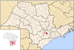
 Location in São Paulo | |
| Coordinates: 23°30′6″S 47°27′29″W / 23.50167°S 47.45806°W | |
| Country | |
| Region | Southeast Brazil |
| State | |
| Metropolitan Region | Sorocaba |
| Founded | 1654 |
| Founded by | Baltazar Fernandes |
| Named for | Sorocaba River |
| Government | |
| • Type | Mayor–Council |
| • Mayor | Rodrigo Maganhato (Republicanos) |
| Area | |
| 450 km2 (170 sq mi) | |
| Elevation | 601 m (1,972 ft) |
| Population (2022)[1] | |
| 723,682 | |
| • Density | 1,600/km2 (4,200/sq mi) |
| • Metro | 2,000,000 |
| Demonym | sorocabano |
| Area code | +55 15 |
| HDI (2010) | 0.798 – high[2] |
| Website | sorocaba |
Sorocaba (Portuguese pronunciation: [soɾoˈkabɐ]) is a municipality in the interior of the state of São Paulo, Brazil. With over 723,000 inhabitants, it is the seventh-largest city in the state and the second-largest outside the Greater São Paulo region, ranking behind only Campinas. It forms its own Metropolitan Region of Sorocaba, comprising 27 municipalities with a total population of 2 million inhabitants, the 15th most populous in Brazil.[3][4][5]
With a surface area of 450,38 km² (or about 170 sq mi), Sorocaba is integrated with Greater São Paulo and the Metropolitan Regions of Campinas, Jundiaí, Paraíba Valley and North Coast and Baixada Santista, forming the São Paulo macrometropolis, which is home to over 30 million people, about three quarters of the state's population and the first such urban agglomeration in the Southern Hemisphere.[6]
The city is highly industrialized, with its industrial production reaching over 120 countries and a GDP of over R$ 32 billion, the 19th-largest in Brazil, surpassing state capitals such as São Luís, Belém, Vitória, Natal, and Florianópolis.[7] Over 22,000 companies operate in the city, 2,000 of which are industries.[8]
- ^ IBGE 2022
- ^ "Archived copy" (PDF). United Nations Development Programme (UNDP). Archived from the original (PDF) on July 8, 2014. Retrieved August 1, 2013.
{{cite web}}: CS1 maint: archived copy as title (link) - ^ "Governo do Estado de São Paulo, Lei Complementar nº 1.241, de 8 de maio de 2014". Archived from the original on 18 October 2014. Retrieved 2015-09-29.
{{cite web}}: CS1 maint: bot: original URL status unknown (link) - ^ "IBGE | Cidades | São Paulo | Sorocaba | Instituto Brasileiro de Geografia e Estatística". cod.ibge.gov.br. Retrieved 2015-11-20.
- ^ "Há 10 anos, Lei Complementar da Alesp criou a Região Metropolitana de Sorocaba". www.al.sp.gov.br (in Brazilian Portuguese). Retrieved 2024-07-03.
- ^ Diego Zanchetta (3 August 2008). "A primeira macrometrópole do hemisfério sul". O Estado de S. Paulo. Archived from the original on 2012-12-05.
- ^ "Sorocaba sobe para o 19º maior PIB do Brasil". IBGE.
- ^ "Dados econômicos Prefeitura de Sorocaba". Archived from the original on 2013-08-19.


