South Australia | |
|---|---|
Nickname(s):
| |
| Country | Australia |
| Before federation | Province of South Australia |
| Settlement | 15 August 1834 |
| Declared as Province | 19 February 1836 |
| Responsible government | 22 April 1857 |
| Federation | 1 January 1901 |
| Capital and largest city | Adelaide |
| Administration | 74 local government areas |
| Demonym(s) |
|
| Government | |
• Monarch | Charles III |
• Governor | Frances Adamson |
• Premier | Peter Malinauskas (ALP) |
| Legislature | Parliament of South Australia |
| Legislative Council | |
| House of Assembly | |
| Judiciary | Supreme Court of South Australia |
| Parliament of Australia | |
• Senate | 12 senators (of 76) |
| 10 seats (of 151) | |
| Area | |
• Land | 984,321[2] km2 (380,048 sq mi) |
| Highest elevation | 1,435 m (4,708 ft) |
| Lowest elevation | −16 m (−52 ft) |
| Population | |
• March 2022 estimate | 1,815,485[3] (5th) |
• Density | 1.84/km2 (4.8/sq mi) (6th) |
| GSP | 2020 estimate |
• Total | AU$108.334 billion[4] (5th) |
• Per capita | AU$61,582 (7th) |
| HDI (2021) | very high · 7th |
| Time zone |
|
• Summer (DST) | UTC+10:30 (ACDT) |
| Postal abbreviation | SA |
| ISO 3166 code | AU–SA |
| Symbols | |
| Bird | Piping shrike (Australian magpie) |
| Fish | Leafy seadragon (Phycodurus eques) |
| Flower | Sturt's Desert Pea (Swainsona formosa) |
| Mammal | Southern hairy-nosed wombat (Lasiorhinus latifrons) |
| Colour(s) | Red, blue, and gold |
| Fossil | Spriggina floundersi |
| Mineral | Bornite, Opal as Gem |
| Website | sa |
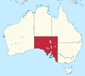
South Australia (commonly abbreviated as SA) is a state in the southern central part of Australia. With a total land area of 984,321 square kilometres (380,048 sq mi),[6] it is the fourth-largest of Australia's states and territories by area, which includes some of the most arid parts of the continent, and with 1.8 million people[3] it is the fifth-largest of the states and territories by population. This population is the second-most highly centralised in the nation after Western Australia, with more than 77% of South Australians living in the capital Adelaide or its environs. Other population centres in the state are relatively small; Mount Gambier, the second-largest centre, has a population of 26,878.[7]
South Australia shares borders with all the other mainland states. It is bordered to the west by Western Australia, to the north by the Northern Territory, to the north-east by Queensland, to the east by New South Wales, to the south-east by Victoria, and to the south by the Great Australian Bight.[8] The state comprises less than 8% of the Australian population and ranks fifth in population among the six states and two territories. The majority of its people reside in greater Metropolitan Adelaide. Most of the remainder are settled in fertile areas along the south-eastern coast and River Murray. The state's colonial origins are unique in Australia as a freely settled, planned British province,[9] rather than as a convict settlement. Colonial government commenced on 28 December 1836, when the members of the council were sworn in near the Old Gum Tree.[10]
As with the rest of the continent, the region has a long history of human occupation by numerous tribes and languages. The South Australian Company established a temporary settlement at Kingscote, Kangaroo Island, on 26 July 1836, five months before Adelaide was founded.[11] The guiding principle behind settlement was that of systematic colonisation, a theory espoused by Edward Gibbon Wakefield that was later employed by the New Zealand Company.[12] The goal was to establish the province as a centre of civilisation for free immigrants, promising civil liberties and religious tolerance. Although its history has been marked by periods of economic hardship, South Australia has remained politically innovative and culturally vibrant. Today, it is known for its fine wine and numerous cultural festivals. The state's economy is dominated by the agricultural, manufacturing and mining industries.
- ^ "Wordwatch: Croweater". ABC NewsRadio. Archived from the original on 15 September 2005. Retrieved 11 October 2011.
- ^ "Area of Australia - States and Territories". 27 June 2014.
- ^ a b "National, state and territory population – March 2021". Australian Bureau of Statistics. 26 September 2022. Archived from the original on 21 November 2022. Retrieved 27 November 2022.
- ^ "5220.0 – Australian National Accounts: State Accounts, 2019–20". Australian Bureau of Statistics. 20 November 2020. Retrieved 20 January 2021.
- ^ "Sub-national HDI - Area Database". Global Data Lab. Retrieved 18 February 2023.
- ^ Area of Australia - States and Territories Geoscience Australia. Retrieved 9 January 2022.
- ^ "2021 Mount Gambier, Census All persons QuickStats | Australian Bureau of Statistics". abs.gov.au. Retrieved 1 January 2024.
- ^ Most Australians describe the body of water south of the continent as the Southern Ocean, rather than the Indian Ocean as officially defined by the International Hydrographic Organization (IHO). In the year 2000, a vote of IHO member nations defined the term "Southern Ocean" as applying only to the waters between Antarctica and 60 degrees south latitude.
- ^ South Australian Police Historical Society Inc. Archived 1 October 2011 at the Wayback Machine Accessed 13 September 2011.
- ^ Anderson, Margaret. "The first reading of the proclamation". SA History Hub. History Trust of South Australia. Retrieved 5 September 2021.
- ^ "Kangaroo Island Council – Welcome". Kangaroo Island Council. Archived from the original on 9 August 2010. Retrieved 10 August 2010.
- ^ "The Wakefield Model of Systematic Colonisation in South Australia". University of South Australia. 2008.[permanent dead link]


