| South Branch Kishwaukee River | |
|---|---|
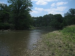
 The South Branch Kishwaukee River flowing through Kishwaukee River State Fish and Wildlife Area, summer 2007 | |
 | |
| Physical characteristics | |
| Source | |
| • location | Shabbona Township, DeKalb County, Illinois |
| • coordinates | 41°46′24″N 88°54′06″W / 41.7733333°N 88.9016667°W |
| • elevation | 900 ft (270 m) |
| Mouth | |
• location | Confluence with the Kishwaukee River near Rockford, Illinois |
• coordinates | 42°12′00″N 88°59′01″W / 42.2°N 88.9836111°W |
• elevation | 709 ft (216 m) |
| Length | 64 mi (103 km) |
| Discharge | |
| • location | Fairdale, IL |
| • average | 305 cu/ft. per sec.[1] |
| Basin features | |
| Progression | South Branch Kishwaukee River → Kishwaukee → Rock → Mississippi → Gulf of Mexico |
| GNIS ID | 422087 |
The South Branch Kishwaukee River is a 63.6-mile-long (102.4 km)[2] tributary of the Kishwaukee River in northern Illinois. The South Branch is the main branch of the Kishwaukee River, joining it 10.6 miles (17.1 km)[2] above its confluence with the Rock River. The South Branch flows through DeKalb County; in 2007 flooding along the tributary inundated areas of DeKalb County and Sycamore, Illinois.
Another stream, also named South Branch Kishwaukee River, flows through Kane County and McHenry County, joining the main stem of the Kishwaukee east of Marengo.
- ^ "USGS Current Conditions for USGS 05439500 SOUTH BRANCH KISHWAUKEE RIVER NR FAIRDALE IL".
- ^ a b U.S. Geological Survey. National Hydrography Dataset high-resolution flowline data. The National Map, accessed May 19, 2011