| South Fork Coquille River | |
|---|---|
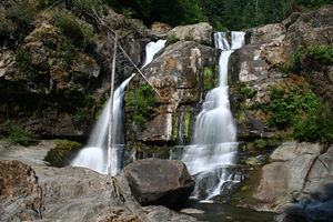
 The lower tier of Coquille River Falls at low water | |
| Location | |
| Country | United States |
| State | Oregon |
| Region | Coos County |
| Cities | Powers, Broadbent, Myrtle Point |
| Physical characteristics | |
| Source | Southern Oregon Coast Range |
| • location | Unnamed ridge, north of Mount Bolivar |
| • coordinates | 42°50′24″N 123°52′30″W / 42.84000°N 123.87500°W[1] |
| • elevation | 3,501 ft (1,067 m)[2] |
| Mouth | Coquille River |
• location | Myrtle Point |
• coordinates | 43°04′49″N 124°08′29″W / 43.08028°N 124.14139°W[1] |
• elevation | 13 ft (4.0 m)[1] |
| Length | 62.8 mi (101.1 km) |
| Basin size | 288 sq mi (750 km2)[3] |
| Discharge | |
| • location | Powers[4] |
| • average | 778 cu ft/s (22.0 m3/s)[5] |
| • minimum | 7.2 cu ft/s (0.20 m3/s) |
| • maximum | 48,900 cu ft/s (1,380 m3/s) |
| Basin features | |
| Tributaries | |
| • left | Johnson Creek, Salmon Creek, Dement Creek, Catching Creek |
| • right | Wooden Rock Creek, Coal Creek, Woodward Creek, Middle Fork Coquille River |
The South Fork Coquille River is the longest tributary of the Coquille River in coastal Oregon in the United States.[3] From its headwaters in the Southern Oregon Coast Range, the river flows northwest to join the North Fork Coquille River at Myrtle Point, forming the main stem Coquille.[6] The South Fork is about 63 miles (101 km) long, and its watershed drains roughly 288 square miles (750 km2) of rural Coos County.[3]
- ^ a b c "South Fork Coquille River". Geographic Names Information System. United States Geological Survey, United States Department of the Interior. November 28, 1980. Retrieved March 18, 2011.
- ^ Source elevation derived from Google Earth search using GNIS source coordinates.
- ^ a b c "Introduction to the Coquille Watershed". Coquille Watershed Association. Archived from the original on November 17, 2016. Retrieved February 21, 2016.
- ^ "Water-Data Report 2009: 14325000 South Fork Coquille River at Powers, OR" (PDF). United States Geological Survey. Retrieved March 18, 2011.
- ^ "Water-Data Report 2009: 14325000 South Fork Coquille River at Powers, OR" (PDF). United States Geological Survey. Retrieved March 18, 2011.
- ^ "United States Topographic Map". United States Geological Survey. Retrieved February 21, 2016 – via Acme Mapper. The map includes mile markers along the main stem and each large Coquille River fork.
