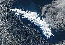
The South Georgia Survey was a series of expeditions to survey and map the island of South Georgia, led by Duncan Carse between 1951 and 1957.[1] Although South Georgia had been commercially exploited as a whaling station during the first half of the 20th century, its interior was generally unknown, and maps were largely based on the original survey by James Cook, who first landed on the island in 1775. The South Georgia Survey was intended to make high-quality modern maps covering the entire island, and took place in four austral summer seasons: 1951–52, 1953–54, 1955–56, and 1956–57.
The survey was funded by the Royal Geographical Society, the Falkland Islands Dependencies, Odhams Press, and other private supporters. The War Office and Ministry of Supply provided 250 man-days of cold-weather rations, along with a loan of clothing and sledging equipment. Transportation to and from South Georgia was provided on the ships used to supply the whaling stations and ferry whale oil back to market. The survey members also often rode along on the whaling vessels to survey the coasts of the island and to be dropped off or picked up for inland work. The survey used the whaling settlement of Grytviken as its base of operations in South Georgia, with lodging provided in the Grytviken jail, which had space for 3–4 men and was generally unoccupied.[2][3]
- ^ Carse, Duncan (March 1959). "The Survey of South Georgia, 1951-7". The Geographical Journal. 125 (1). Wiley-Blackwell: 20–37. doi:10.2307/1791883. JSTOR 1791883.
- ^ Cite error: The named reference
polarec51was invoked but never defined (see the help page). - ^ "South Georgia Survey 1951–57". Scott Polar Research Institute. 2012-08-17.