| South Melbourne Melbourne, Victoria | |||||||||||||||
|---|---|---|---|---|---|---|---|---|---|---|---|---|---|---|---|
 | |||||||||||||||
 | |||||||||||||||
| Coordinates | 37°50′06″S 144°57′36″E / 37.835°S 144.960°E | ||||||||||||||
| Population | 11,548 (2021 census)[1] | ||||||||||||||
| • Density | 4,620/km2 (11,960/sq mi) | ||||||||||||||
| Established | 1840s | ||||||||||||||
| Postcode(s) | 3205 | ||||||||||||||
| Elevation | 10 m (33 ft) | ||||||||||||||
| Area | 2.5 km2 (1.0 sq mi) | ||||||||||||||
| Location | 3 km (2 mi) from Melbourne | ||||||||||||||
| LGA(s) | City of Port Phillip | ||||||||||||||
| State electorate(s) | Albert Park | ||||||||||||||
| Federal division(s) | Macnamara | ||||||||||||||
| |||||||||||||||

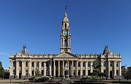
South Melbourne is an inner suburb in Melbourne, Victoria, Australia, 3 kilometres (1.9 mi) south of Melbourne's Central Business District, located within the City of Port Phillip local government area. South Melbourne recorded a population of 11,548 at the 2021 census.[1]
Historically known as Emerald Hill, South Melbourne was one of the first of Melbourne's suburbs to adopt full municipal status and is one of Melbourne's oldest suburban areas, notable for its well preserved Victorian era streetscapes.
The current boundaries are complex. Starting at the east end of Dorcas Street, it runs along the rear of properties on St Kilda Road, then south along Albert Road, north up Canterbury Road, along the rear of the north side of St Vincent Place, zigzags west along St Vincent Street, then north up Pickles Street. There is then an arm of former industrial land to the west between Boundary Road, the freeway and Ferrars Street. It then runs along Market Street to Kingsway, then up Dorcas Street to St Kilda Road.
- ^ a b Australian Bureau of Statistics (28 June 2022). "South Melbourne (Suburbs and Localities)". 2021 Census QuickStats. Retrieved 17 July 2022.
