South Nyack, New York | |
|---|---|
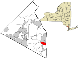
 Location in Rockland County and the state of New York. | |
| Coordinates: 41°5′2″N 73°55′23″W / 41.08389°N 73.92306°W | |
| Country | United States |
| State | New York |
| County | Rockland |
| Incorporated | 1878 |
| Dissolved | 2022 |
| Area | |
| • Total | 1.68 sq mi (4.35 km2) |
| • Land | 0.60 sq mi (1.56 km2) |
| • Water | 1.08 sq mi (2.79 km2) |
| Elevation | 72 ft (22 m) |
| Population (2020) | |
| • Total | 2,699 |
| • Density | 4,483.39/sq mi (1,729.64/km2) |
| Time zone | UTC-5 (Eastern (EST)) |
| • Summer (DST) | UTC-4 (EDT) |
| ZIP code | 10960 |
| Area code | 845 |
| FIPS code | 36-69441 |
| GNIS feature ID | 0965828 |
| Website | southnyack.ny.gov |

South Nyack is a hamlet and census-designated place in the town of Orangetown in Rockland County, New York, United States. It is located north of Grand View-on-Hudson, northeast of Orangeburg, east of Blauvelt State Park, south of Nyack and west of the Hudson River. The hamlet is the western terminus of the Tappan Zee Bridge. Its population was 3,510 at the 2010 census.[2] The hamlet was formerly incorporated as a village from 1878 until 2022.[3]
- ^ "ArcGIS REST Services Directory". United States Census Bureau. Retrieved September 20, 2022.
- ^ "Profile of General Population and Housing Characteristics: 2010 Demographic Profile Data (DP-1): South Nyack village, New York". United States Census Bureau. Retrieved February 6, 2012.
- ^ Hall, Phil (April 1, 2022). "Village of South Nyack officially dissolved".
