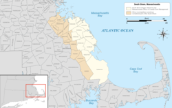
South Shore
Irish Riviera | |
|---|---|
 The South Shore region of Massachusetts | |
| Coordinates: 42°00′N 70°45′W / 42°N 70.75°W | |
| Country | United States |
| State | Massachusetts |
| Cities and towns | Braintree, Cohasset, Duxbury, Hingham, Hull, Kingston, Marshfield, Plymouth, Quincy, Rockland, Scituate and Weymouth, sometimes adding inland towns |
| Area | |
| • Total | 632.9 sq mi (1,639 km2) |
| Population (2010) | |
| • Total | 541,364 |
| • Density | 860/sq mi (330/km2) |
| Largest city (population) | Quincy (101,636) |
| Largest city (land) | Plymouth (134 square miles) |
The South Shore of Massachusetts is a geographic region stretching south and east from Boston toward Cape Cod along the shores of Massachusetts Bay and Cape Cod Bay. It is subject to varying descriptions including municipalities in eastern Norfolk and Plymouth counties. The South Shore is an affluent area. The median income of the region as of 2020 is $104,691. The median home value of the region as of 2020 is $574,831.
Depending on its geographical definition, the South Shore is composed of a mix of suburban towns, mid-sized industrial cities and rural towns. Massachusetts' heaviest concentration of Irish-American residents and descendants from ancestors from Ireland is on the South Shore,[1] and 6 of the United States' 10 most Irish towns are located on the South Shore, which is sometimes referred to locally as the Irish Riviera.[2][3]
- ^ Schworm, Peter. "Digging Their Celtic Roots." The Boston Globe, June 19, 2005
- ^ "Massachusetts rules list of Irish towns". ePodunk. Retrieved 12 January 2011.
- ^ Sweeney, Emily. "How the South Shore became the Irish Riviera". The Boston Globe. Retrieved 12 January 2011.