| South Willingham | |
|---|---|
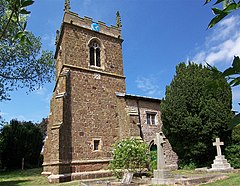
 St Martin's Church, South Willingham | |
Location within Lincolnshire | |
| Population | 160 (2011)[1] |
| OS grid reference | TF195833 |
| • London | 125 mi (201 km) S |
| District | |
| Shire county | |
| Region | |
| Country | England |
| Sovereign state | United Kingdom |
| Post town | Market Rasen |
| Postcode district | LN8 |
| Dialling code | 01507 |
| Police | Lincolnshire |
| Fire | Lincolnshire |
| Ambulance | East Midlands |
| UK Parliament | |
South Willingham is a village and civil parish in the East Lindsey district of Lincolnshire, England, and partly within the Lincolnshire Wolds Area of Outstanding Natural Beauty, . It is situated 1 mile (2 km) south of the A157 Lincoln to Louth road, 15 miles (24 km) west of Lincoln, where the central Lincolnshire Vale and the Lincolnshire Wolds meet. Its population was 160 at the 2011 census, down from a maximum of 341 in 1851.
Much of the village formed part of the Heneage Estate; Hainton Hall is a mile north of the village. At South Willingham is Belmont transmitting station, the second tallest structure in the UK.
The geology under the village is unusually complex with four separate bedrocks located within the parish. Sand, gravel and clay have all been quarried in the parish; the clay pit supplied a brickworks in the Victorian era.
- ^ "South Willingham", Citypopulation.de
