| The Sperrins | |
|---|---|
| Sliabh Speirín (Irish)[1] | |
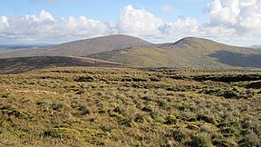
 Looking towards Sawel and Dart mountains | |
| Highest point | |
| Peak | Sawel Mountain |
| Elevation | 678 m (2,224 ft) |
| Geography | |
 | |
| Sovereign state | United Kingdom |
| Constituent country | Northern Ireland |
| Counties | County Tyrone, County Londonderry |
| Range coordinates | 54°48′00″N 7°04′59″W / 54.8°N 7.083°W |
| Geology | |
| Orogeny | Caledonian orogeny |
| Rock type(s) | Schist, quartzite,[2] granite, basalt, rhyolite |
The Sperrins or Sperrin Mountains (Irish: Sliabh Speirín)[3] are a mountain range in Northern Ireland. The range stretches from Strabane and Mullaghcarn in the west, to Slieve Gallion and the Glenshane Pass in the east, in the counties of Tyrone and Londonderry. The landscape is mostly moorland and blanket bog. The region has a population of some 150,000 and is a designated Area of Outstanding Natural Beauty.
- ^ "Sperrin Mountains/Sliabh Speirín". Placenames Database of Ireland.
- ^ "The Rock Cycle, Schist, Co Tyrone, The Geological Society". Archived from the original on 22 May 2014. Retrieved 3 March 2013.
- ^ Northern Ireland Place-Name Project