| Spring Creek Dam | |
|---|---|
 | |
| Official name | Spring Creek Debris Dam |
| Location | Shasta-Trinity National Forest Shasta County, California |
| Coordinates | 40°37′47″N 122°28′27″W / 40.6298°N 122.4741°W |
| Construction began | 1961 |
| Opening date | 1963 |
| Operator(s) | Bureau of Reclamation |
| Dam and spillways | |
| Impounds | Spring Creek |
| Height | 196 ft (60 m) |
| Length | 1,110 ft (340 m) |
| Spillway type | Uncontrolled concrete overflow |
| Spillway capacity | 5,260 cubic feet per second (149 m3/s) |
| Reservoir | |
| Creates | Spring Creek Reservoir |
| Total capacity | 5,870 acre⋅ft (7,240 dam3) |
| Catchment area | 16 sq mi (41 km2) |
| Power Station | |
| Turbines | 2x 90 MW Francis turbines |
| Installed capacity | 150 MW 180 MW (max) |
| U.S. Geological Survey Geographic Names Information System: Spring Creek Dam | |
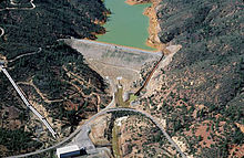
Spring Creek Debris Dam is an earthfill dam on Spring Creek, a tributary of the Sacramento River, in Shasta County in the U.S. state of California. Completed in 1963, the dam, maintained by the U.S. Bureau of Reclamation, serves primarily to collect severe acid mine drainage stemming from the Iron Mountain Mine.[1] The dam forms the Spring Creek Reservoir, less than 1 mile (1.6 km) long. Spring Creek and South Fork Spring Creek flow into the reservoir from a 16-square-mile (41 km2) watershed.[2] The dam is directly upstream from the city of Keswick, California and the Keswick Reservoir.[3] The operation is part of the Trinity River Division of the Central Valley Project.[1]
The primary purpose of the Spring Creek Dam was to collect acid mine drainage from the old Iron Mountain Mine, which was heavily polluting Spring Creek and its tributaries. The dam was built in response to these pollutants that were contaminating the Sacramento River, the primary water supply for millions of Californians. Although the watershed is small in comparison to that of the Sacramento River, the stream is among the most polluted and acidic in the world.[4][5]
The dam and reservoir, along with other treatment structures built at and below the mine, have successfully reduced the dry weather pollution of Spring Creek by up to ninety-five percent. Problems, though, still occur mainly in the form of large uncontrolled spills from the reservoir. Several concerns about the structural integrity and safety of the dam, both physically and biologically, arose in the 1990s. Emergency releases from Shasta Lake, often in the value of thousands of acre feet of water, have occurred from time to time to dilute massive acid spills from the Spring Creek drainage.[5]
- ^ a b "CVP- Shasta/Trinity River Divisions". U.S. Bureau of Reclamation. Archived from the original on May 2, 2008. Retrieved 2009-04-15.
- ^ Google Maps (Map). Cartography by NAVTEQ. Google Maps. 2009. Retrieved 2009-07-09.
- ^ "Spring Creek Debris Dam". U.S. Bureau of Reclamation. Archived from the original on 2011-06-14. Retrieved 2009-04-15.
- ^ Lee, Lavender. "Iron Mountain Mine". Online Data Resources of California. Retrieved 2009-04-15.
- ^ a b "Abandoned Mine Lands Case Study" (PDF). U.S. Environmental Protection Agency. Retrieved 2009-04-15.