Springdale, Utah | |
|---|---|
 | |
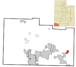
 Location in Washington County and the state of Utah | |
| Coordinates: 37°11′4″N 112°59′59″W / 37.18444°N 112.99972°W | |
| Country | United States |
| State | Utah |
| County | Washington |
| Settled | 1862 |
| Named for | Springs |
| Government | |
| • Mayor | Stanley J. Smith |
| • Council members | Randy Aton, Suzanne Elger, Adrian Player, Lisa Zumpft |
| Area | |
| • Total | 4.62 sq mi (11.96 km2) |
| • Land | 4.62 sq mi (11.96 km2) |
| • Water | 0.00 sq mi (0.00 km2) |
| Elevation | 3,898 ft (1,188 m) |
| Population (2010) | |
| • Total | 529 |
| • Estimate (2019)[2] | 629 |
| • Density | 136.24/sq mi (52.60/km2) |
| Time zone | UTC-7 (Mountain (MST)) |
| • Summer (DST) | UTC-6 (MDT) |
| ZIP codes | 84767, 84779 |
| Area code | 435 |
| FIPS code | 49-71840[3] |
| GNIS feature ID | 1432867[4] |
Springdale is a town in Washington County, Utah, United States. The population was 529 at the 2010 census. It is located immediately outside the boundaries of Zion National Park, and is oriented around the resulting tourist industry.[5] It was originally settled as a Mormon farming community in 1862 by evacuees from the flooding of nearby Northrop.[6]
- ^ "2019 U.S. Gazetteer Files". United States Census Bureau. Retrieved August 7, 2020.
- ^ Cite error: The named reference
USCensusEst2019CenPopScriptOnlyDirtyFixDoNotUsewas invoked but never defined (see the help page). - ^ "U.S. Census website". United States Census Bureau. Retrieved January 31, 2008.
- ^ "US Board on Geographic Names". United States Geological Survey. October 25, 2007. Retrieved January 31, 2008.
- ^ Carlisle, Nate (June 12, 2012). "Audit: Small town Utah cops targeted foreign tourists". The Salt Lake Tribune. The Salt Lake Tribune. Retrieved January 11, 2013.
- ^ Webb, R. H.; Blainey, J. B.; Hyndman, D. W. (2002). "Paleoflood Hydrology of the Paria River, Southern Utah and Northern Arizona, USA". In House, P. Kyle (ed.). Ancient floods, modern hazards: principles and applications of paleoflood hydrology. Vol. 1. American Geophysical Union. p. 297.