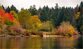
| Sproat Lake | |
|---|---|
 Fall colours at Sproat Lake | |
| Location | Vancouver Island, British Columbia |
| Coordinates | 49°16′N 125°02′W / 49.267°N 125.033°W |
| Basin countries | Canada |
| Surface area | 3,775 ha (9,330 acres) |
| Average depth | 74 m (243 ft) |
| Max. depth | 195 m (640 ft) |
| Shore length1 | 90.8 km (56.4 mi) |
| References | [1] |
| 1 Shore length is not a well-defined measure. | |
Sproat Lake is a lake on central Vancouver Island in British Columbia, Canada. It was known as Kleecoot, meaning "wide open" by local indigenous people.
Roughly cross-shaped with four arms, it is over 25 kilometres in length, and has 90.8 kilometres of shoreline.[1] Home of the last Martin Mars type waterbombers, and near Port Alberni, Sproat Lake is a popular summer recreational area for the Alberni Valley. Highway 4 runs along its north shore.[2]
The lake maintains a small wintering population of Marbled Murrelets which also nest in the area, the only freshwater alcids on Earth.[citation needed]
In August of 2023, Sproat Lake was voted British Columbia's Best Lake by CBC's viewers.[3]
- ^ a b "Vancouver Island Large Lakes Management Plan" (PDF). Fish and Wildlife Branch, Ministry of Forests, Lands and Natural Resource Operations.
- ^ Port Alberni Tourism Retrieved December 6, 2016
- ^ Sproat Lake in Port Alberni voted B.C.'s best lake in CBC bracket Retrieved August 4, 2023
