St. Catharine, Missouri | |
|---|---|
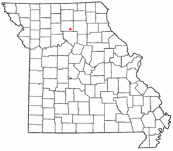
 Location of St. Catharine in Missouri | |
| Coordinates: 39°47′42″N 92°59′40″W / 39.79500°N 92.99444°W | |
| Country | United States |
| State | Missouri |
| County | Linn |
| Area | |
| • Total | 0.74 sq mi (1.91 km2) |
| • Land | 0.73 sq mi (1.90 km2) |
| • Water | 0.00 sq mi (0.01 km2) |
| Elevation | 830 ft (250 m) |
| Population (2020) | |
| • Total | 78 |
| • Density | 106.41/sq mi (41.08/km2) |
| FIPS code | 29-64046 |
| GNIS feature ID | 2587111[2] |
Saint Catharine or St. Catharine is an unincorporated community and census-designated place in southeast Linn County, Missouri, United States.[2] Saint Catharine is located approximately four miles east of Brookfield on Missouri Route 11 in the Yellow Creek Township. The Chicago, Burlington and Quincy Railroad passes the south side of the community.[3]

- ^ "ArcGIS REST Services Directory". United States Census Bureau. Retrieved September 5, 2022.
- ^ a b c U.S. Geological Survey Geographic Names Information System: St. Catharine, Missouri
- ^ Bucklin, MO, 7.5 Minute Topographic Quadrangle, USGS, 1949