| St. Cyril Peak | |
|---|---|
 St. Cyril Peak from Bransfield Strait, with Needle Peak in the foreground. | |
| Highest point | |
| Elevation | 1,505 m (4,938 ft) |
| Geography | |
 | |
| Location | Livingston Island, South Shetland Islands, Antarctica |
| Parent range | Tangra Mountains |
| Climbing | |
| First ascent | unclimbed |


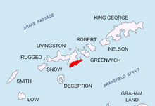
St. Cyril Peak (Bulgarian: връх Св. Кирил, romanized: vrah Sv. Kiril, IPA: [ˈvrɤx svɛˈti ˈkiriɫ]) rises to 1,505m in Friesland Ridge in Tangra Mountains on Livingston Island in the South Shetland Islands, Antarctica. The peak is linked to St. Methodius Peak to the southwest by Vladaya Saddle and surmounts Ruen Icefall to the west, Macy Glacier to the east and Prespa Glacier to the south.
The peak is "named after St. Cyril (827-869 AD) who, together with St. Methodius, created the Glagolitic alphabet and translated the Holy Books into Bulgarian language".[1]
- ^ St. Cyril Peak. SCAR Composite Antarctic Gazetteer.