| Saint Francois Mountains | |
|---|---|
 A view towards the St. Francois range from Knob Lick Mountain, a granite and rhyolite knob on the edge of the range | |
| Highest point | |
| Peak | Taum Sauk Mountain |
| Elevation | 1,772 ft (540 m) |
| Coordinates | 37°34′13″N 90°43′40″W / 37.57028°N 90.72778°W |
| Geography | |
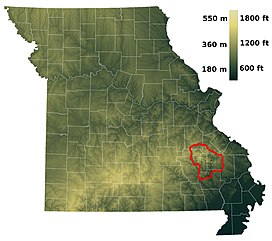
 A relief map of Missouri showing the St. Francois Mountain region (red) | |
| Country | United States |
| State | Missouri |
| Geology | |
| Rock age | Precambrian |
| Rock type | igneous |
The St. Francois Mountains in southeast Missouri are a mountain range of Precambrian igneous mountains rising over the Ozark Plateau. This range is one of the oldest exposures of igneous rock in North America. The name of the range is spelled out as Saint Francois Mountains in official GNIS sources,[1] but it is sometimes misspelled in use as St. Francis Mountains to match the anglicized pronunciation of both the range and St. Francois County.[2][3][4]
- ^ U.S. Geological Survey Geographic Names Information System: Saint Francois Mountains
- ^ Tilton, G. R.; Wetherill, G. W.; Davis, G. L. (1962). "Mineral Ages from the Wichita and Arbuckle Mountains, Oklahoma, and the St. Francis Mountains, Missouri". Journal of Geophysical Research. 67 (10): 4011. Bibcode:1962JGR....67.4011T. doi:10.1029/jz067i010p04011.
- ^ "U.S. Geological Survey Photographic Library". libraryphoto.cr.usgs.gov. Archived from the original on 2012-02-17.
- ^ "Landslide Overview Map of the Conterminous United States. Geological Survey Professional Paper 1183".