| St. Jones River Tributary to Delaware Bay | |
|---|---|
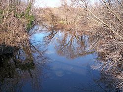
 The St. Jones River in Dover in 2006 | |
| Location | |
| Country | United States |
| State | Delaware |
| County | Kent |
| City | Dover |
| Physical characteristics | |
| Source | Silver Lake |
| • location | Dover |
| • coordinates | 39°10′06″N 75°31′18″W / 39.16833°N 75.52167°W[1] |
| • elevation | 13 ft (4.0 m)[1] |
| Mouth | Delaware Bay |
• location | Bowers |
• coordinates | 39°03′57″N 75°24′03″W / 39.06583°N 75.40083°W[1] |
• elevation | 0 ft (0 m)[1] |
| Length | 13 mi (21 km)[2] |
| Basin size | 36 sq mi (93 km2)[3] |
| Discharge | |
| • location | Bowers Beach, Delaware |
| • average | 107.65 cu ft/s (3.048 m3/s) at mouth with Delaware Bay[4] |
| Basin features | |
| Progression | Delaware Bay → Atlantic Ocean |
| River system | Delaware Bay |
| Tributaries | |
| • left | Fork Branch |
| • right | Puncheon Run Isaac Branch Tidbury Creek Cypress Branch Beaver Gut Ditch Trunk Ditch |
| Waterbodies | Silver Lake |
| Bridges | E Division Street, E Lookerman Street, Martin Luther King, jr. Blvd., US 13, Puncheon Run Connector, E Lebanon Road, DE 1 |
The St. Jones River is a river flowing to Delaware Bay in central Delaware in the United States. It is 12.8 miles (20.6 km) long[2] and drains an area of 36 square miles (93 km2) on the Atlantic Coastal Plain.
- ^ a b c d U.S. Geological Survey Geographic Names Information System: Saint Jones River
- ^ a b U.S. Geological Survey. National Hydrography Dataset high-resolution flowline data. The National Map Archived 2012-03-29 at the Wayback Machine, accessed April 1, 2011
- ^ United States Environmental Protection Agency (2006-12-14). "Total Maximum Daily Loads (TMDLs) for Bacteria and Nutrient Impairments on the St. Jones River Watershed, Delaware". Retrieved 2007-01-30.
- ^ "St. Jones River Watershed Report". Waters Geoviewer. US EPA. Retrieved 19 October 2019.
