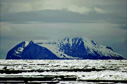
 View of Cape Upright, St. Matthew Island | |
 | |
| Geography | |
|---|---|
| Location | Bering Sea |
| Coordinates | 60°24′31″N 172°43′12″W / 60.40861°N 172.72000°W |
| Archipelago | none |
| Area | 137.857 sq mi (357.05 km2) |
| Length | 31.7 mi (51 km) |
| Highest elevation | 1,476 ft (449.9 m) |
| Administration | |
United States | |
| State | Alaska |
| Demographics | |
| Population | Uninhabited |
St. Matthew Island (Russian: Остров Святого Матвея, romanized: Ostrov Svyatogo Matveya) is an uninhabited, remote island in the Bering Sea in Alaska, 183 miles (295 km) west-northwest of Nunivak Island. The entire island's natural scenery and wildlife is protected as it is part of the Bering Sea unit of the Alaska Maritime National Wildlife Refuge and as the Bering Sea Wilderness.
The island has a land area of 137.857 sq mi (357.05 km2), making it the 43rd largest island in the United States. Its most southerly point is Cape Upright which features cliff faces which exceed 1,000 feet (300 m). Similar heights are found at Glory of Russia Cape on the north, and the highest point, 1,476 feet (450 m) above sea level, lies south from the island center.
There is a small island off its northwestern point called Hall Island. The 3.1 miles (5.0 km) wide sound between the two islands is called Sarichef Strait. A small rocky islet called Pinnacle Rock lies 9.3 miles (15.0 km) to the south of Saint Matthew Island.
The United States Coast Guard maintained a staffed LORAN station on the island during the 1940s.

