St. Stephens | |
|---|---|
CDP | |
 St. Stephens Courthouse in "New" St. Stephens, completed in 1854. | |
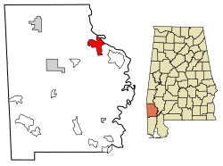
 Location of St. Stephens in Washington County, Alabama. | |
| Coordinates: 31°32′25″N 88°3′19″W / 31.54028°N 88.05528°W | |
| Country | United States |
| State | Alabama |
| County | Washington |
| Area | |
| • Total | 10.01 sq mi (25.93 km2) |
| • Land | 9.88 sq mi (25.58 km2) |
| • Water | 0.14 sq mi (0.35 km2) |
| Elevation | 226 ft (69 m) |
| Population (2020) | |
| • Total | 415 |
| • Density | 42.02/sq mi (16.22/km2) |
| Time zone | UTC-6 (Central (CST)) |
| • Summer (DST) | UTC-5 (CDT) |
| ZIP code | 36569 |
| Area code | 251 |
| FIPS code | 01-67584 |
| [2][3] | |
St. Stephens is an unincorporated census-designated place in Washington County, Alabama, United States. Its population is 580.[4] Located near the Tombigbee River in the southwestern part of the state and 67 miles north of Mobile, it is composed of two distinct sites: Old St. Stephens and New St. Stephens.[2][3] The Old St. Stephens site lies directly on the river and is no longer inhabited. It was the territorial capital of the Alabama Territory.[5][6] Now encompassed by the Old St. Stephens Historical Park, it is listed on the National Register of Historic Places.[7][8]
Changes in the territorial capital and transportation resulted in the Old St. Stephens site being bypassed by development. "New" St. Stephens developed two miles inland around a railway station, but adjacent to the old site. It is the location of the post office, Baptist and Methodist churches, and residences.[9] It has one building listed on the National Register and another on the Alabama Register of Landmarks and Heritage.[7][10]
- ^ "2020 U.S. Gazetteer Files". United States Census Bureau. Retrieved October 29, 2021.
- ^ a b U.S. Geological Survey Geographic Names Information System: St. Stephens, Alabama (New Saint Stephens)
- ^ a b U.S. Geological Survey Geographic Names Information System: Old Saint Stephens (historical)
- ^ "U.S. Census website". United States Census Bureau. Retrieved May 14, 2011.
- ^ "Capitals of Alabama" Archived October 8, 2012, at the Wayback Machine Alabama Department of Archives & History (October 29, 2001). Retrieved May 4, 2005
- ^ "Old St. Stephens". Encyclopedia of Alabama. Auburn University. Retrieved June 21, 2011.
- ^ a b "National Register Information System". National Register of Historic Places. National Park Service. March 13, 2009.
- ^ "Visit the Park". Old St. Stephens Historical Commission. Archived from the original on July 30, 2013. Retrieved May 3, 2017.
- ^ ZIP Code Lookup
- ^ "The Alabama Register of Landmarks & Heritage" (PDF). preserveala.org. Alabama Historical Commission. May 31, 2011. Archived from the original (PDF) on June 6, 2011. Retrieved June 6, 2011.
