| St. Mary's | |
|---|---|
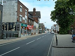
 St Mary's Street. Looking North. | |
Location within Southampton | |
| Unitary authority | |
| Ceremonial county | |
| Region | |
| Country | England |
| Sovereign state | United Kingdom |
| Post town | SOUTHAMPTON |
| Postcode district | SO14 |
| Dialling code | 023 |
| Police | Hampshire and Isle of Wight |
| Fire | Hampshire and Isle of Wight |
| Ambulance | South Central |
| UK Parliament | |
St Mary's is an inner city area of Southampton in England. It consists of two areas separated by Six Dials junction. The northern section of the district is bounded by St Mary's Road and some streets to the west and the area to the east is Nicholstown-Newtown. The northern section is home to the fire station.[1]
The majority of St Mary's is in the southern portion, to the east of St Mary Street. This is where St Mary's church is located, from which the suburb's name originates. The southern section is also home to the Golden Grove area. It is bordered on the east by the rail lines (the other side of these lines is the district of Chapel). It gives its name to St Mary's Stadium, where Southampton Football Club play, although the stadium itself is in the neighbouring suburb of Northam.
- ^ "St Mary's Fire Station". hantsfire.gov.uk.
