Stacy | |
|---|---|
 City Hall | |
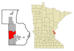
 Location of the city of Stacy within Chisago County, Minnesota | |
| Coordinates: 45°22′33″N 92°59′52″W / 45.37583°N 92.99778°W | |
| Country | United States |
| State | Minnesota |
| County | Chisago |
| Area | |
| • Total | 3.30 sq mi (8.54 km2) |
| • Land | 3.23 sq mi (8.37 km2) |
| • Water | 0.07 sq mi (0.17 km2) |
| Elevation | 899 ft (274 m) |
| Population (2020) | |
| • Total | 1,703 |
| • Density | 527.08/sq mi (203.49/km2) |
| Time zone | UTC-6 (Central (CST)) |
| • Summer (DST) | UTC-5 (CDT) |
| ZIP code | 55079 |
| Area code | 651 |
| FIPS code | 27-62320[3] |
| GNIS feature ID | 2395946[2] |
| Website | www.stacymn.org |
Stacy is a city in Chisago County, Minnesota, United States, along the Sunrise River. The population was 1,456 at the 2010 census.[4]
Interstate 35 serves as a main route for the community.
- ^ "2020 U.S. Gazetteer Files". United States Census Bureau. Retrieved July 24, 2022.
- ^ a b U.S. Geological Survey Geographic Names Information System: Stacy, Minnesota
- ^ "U.S. Census website". United States Census Bureau. Retrieved January 31, 2008.
- ^ "2010 Census Redistricting Data (Public Law 94-171) Summary File". American FactFinder. U.S. Census Bureau, 2010 Census. Retrieved April 23, 2011.[dead link]