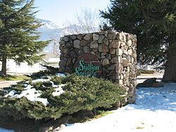
Stallion Springs | |
|---|---|
 the entrance to the town | |
 Location in Kern County and the state of California | |
| Coordinates: 35°05′20″N 118°38′33″W / 35.08889°N 118.64250°W | |
| Country | |
| State | |
| County | Kern |
| Government | |
| • Senate | Jean Fuller (R) |
| • Assembly | Vince Fong (R) |
| • U. S. Congress | Kevin McCarthy (R) |
| Area | |
| • Total | 16.453 sq mi (42.612 km2) |
| • Land | 16.429 sq mi (42.551 km2) |
| • Water | 0.024 sq mi (0.062 km2) 0.14% |
| Elevation | 3,783 ft (1,153 m) |
| Population | |
| • Total | 3,139 |
| • Density | 190/sq mi (74/km2) |
| Time zone | UTC-8 (PST) |
| • Summer (DST) | UTC-7 (PDT) |
| ZIP code | 93561 |
| Area code | 661 |
| FIPS code | 06-73868 |
| GNIS feature ID | 1853417 |
Stallion Springs is a census-designated place (CDP) in the Tehachapi Mountains, in Kern County, California, USA. The population was 2,488 at the 2010 census, up from 1,522 at the 2000 census. Stallion Springs is located in Cummings Valley within the Greater Tehachapi area.
- ^ U.S. Census Archived 2012-01-25 at the Wayback Machine
- ^ U.S. Geological Survey Geographic Names Information System: Stallion Springs, California
- ^ "US Census Bureau". www.census.gov. Retrieved September 3, 2024.
