| Steens Mountain Wilderness | |
|---|---|
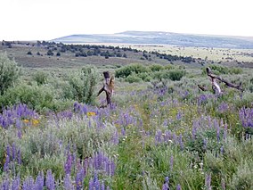
 Steens Mountain wildflowers | |
| Location | Harney County, Oregon, United States |
| Nearest city | Burns, Oregon |
| Coordinates | 42°40′00″N 118°45′04″W / 42.6665536°N 118.7510263°W[1] |
| Area | 170,166 acres (68,864 ha)[2] |
| Established | October 30, 2000 |
| Governing body | Bureau of Land Management |

The Steens Mountain Wilderness is a wilderness area surrounding a portion of Steens Mountain of southeastern Oregon in the United States. The reserve falls within the Steens Mountain Cooperative Management and Protection Area (CMPA). Both the reserve and the CMPA are administered by the Bureau of Land Management. The wilderness area encompasses 170,166 acres (68,864 ha) of the CMPA's total 428,156 acres (173,269 ha).[3] 98,859 acres (40,007 ha) of the Wilderness are protected from grazing and free of cattle.[4]
- ^ "Steens Mountain Wilderness". Geographic Names Information System. United States Geological Survey, United States Department of the Interior. Retrieved 2011-08-21.
- ^ "Wilderness Acreage Breakdown for The Steens Mountain Wilderness". Wilderness.net. Archived from the original on 2010-06-20. Retrieved 2010-07-02.
- ^ "Steens Mountain". Bureau of Land Management. Archived from the original on 2015-08-25. Retrieved 2007-11-30.
- ^ "Steens Mountain Wilderness". Wilderness.net. Archived from the original on 2016-09-23. Retrieved 2007-11-30.
