| Steung Saen River | |
|---|---|
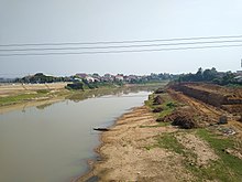
 Stung Saen at Kampong Thom | |
 | |
| Native name | ស្ទឹងសែន (Khmer) |
| Location | |
| Country | Cambodia |
| Provinces | Preah Vihear Province and Kampong Thom Province |
| Physical characteristics | |
| Mouth | Tonlé Sap River |
• coordinates | 12°31′59″N 104°26′15″E / 12.53312°N 104.43741°E |
| Length | 520 km (320 mi)[1] |
| Basin size | 16,344 km2 (1,634,400 ha)[1] |
| Basin features | |
| Average runoff | 11,685 m3 per second[2] |

Steung Saen River (ស្ទឹងសែន), sometimes spelt Steung Sen, is a river in Cambodia. It is a major tributary of the Tonlé Sap River.[2] The Stung Sen River Basin is the largest among the 11 main tributaries around Tonlé Sap with a catchment surface of 16,344 km2 (1,634,400 ha).[1] The basin receives about 1,500 mm (59 in) of rain per year.[2]
The river passes through Preah Vihear Province and Kampong Thom Province. The northern extent of the river basin corresponds to the border with Thailand as in 1904, Siam and the French colonial authorities ruling Cambodia formed a joint commission to demarcate their mutual border to largely follow the watershed line of the Dângrêk mountain range.
- ^ a b c Prof. Puy LIM (Vice chairman of Tonle Sap Authority). "Integrated River Basin Management In Cambodia Stung Sen river basin (Oct 2014)". Retrieved 3 August 2021.
- ^ a b c Water Environment Partnership in Asia. "State of Water: Cambodia". Retrieved 4 August 2021.