Stevens Village
Denyeet | |
|---|---|
 Home in Stevens Village, 2009 | |
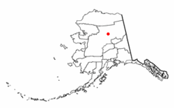
 Location of Stevens Village, Alaska | |
| Coordinates: 66°0′19″N 149°6′11″W / 66.00528°N 149.10306°W | |
| Country | United States |
| State | Alaska |
| Census Area | Yukon-Koyukuk |
| Government | |
| • State senator | Click Bishop (R) |
| • State rep. | Mike Cronk (R) |
| Area | |
| • Total | 13.29 sq mi (34.43 km2) |
| • Land | 11.65 sq mi (30.17 km2) |
| • Water | 1.64 sq mi (4.25 km2) |
| Population (2020) | |
| • Total | 37 |
| • Density | 3.18/sq mi (1.23/km2) |
| Time zone | UTC-9 (Alaska (AKST)) |
| • Summer (DST) | UTC-8 (AKDT) |
| ZIP code | 99774 |
| Area code | 907 |
| FIPS code | 02-73290 |
Stevens Village (Denyeet in Koyukon) is a census-designated place (CDP) in Yukon-Koyukuk Census Area, Alaska, United States. The population was 78 at the 2010 census, down from 87 in 2000.
The village is named for its first chief, Skidedlestalk “Old Steven” Stevens (1850-d. 1912~1920).[2][3]
- ^ "2020 U.S. Gazetteer Files". United States Census Bureau. Retrieved October 29, 2021.
- ^ Orth, Donald J. (1967). Dictionary of Alaska Place Names. U.S. Government Printing Office.; Phillips, James W. (1973). Alaska-Yukon Place Names. University of Washington Press. ISBN 0-295-95259-8.
- ^ 13th Census of the United States, Census of Alaska, 4th District, Stevens Village (December 25-26, 1909). Retrieved February 23, 2019.