Stirling | |
|---|---|
| Village of Stirling | |
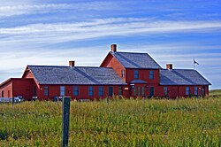
 Galt Historic Railway Park north of Stirling. | |
| Nickname(s): | |
| Motto: Experience The History | |
Location of Stirling in Alberta | |
| Coordinates: 49°30′08″N 112°31′00″W / 49.50222°N 112.51667°W | |
| Country | Canada |
| Province | Alberta |
| Region | Southern Alberta |
| Census division | 2 |
| Municipal district | County of Warner No. 5 |
| Founded | May 5, 1899 |
| Incorporated[3] | |
| • Village | September 3, 1901 |
| Government | |
| • Mayor | Trevor Lewington |
| • Governing body | Stirling Village Council |
| • CAO | Scott Donselaar |
| • MP | Glen Motz |
| • MLA | Grant Hunter |
| Area (2021)[5] | |
| • Land | 2.7 km2 (1.0 sq mi) |
| Elevation | 935 m (3,068 ft) |
| Population | |
| • Total | 1,164 |
| • Density | 431.8/km2 (1,118/sq mi) |
| Time zone | UTC−7 (MST) |
| • Summer (DST) | UTC−6 (MDT) |
| Postal code span | |
| Area code | +1-403 |
| Highways | Highway 4 Highway 61 Highway 846 |
| Waterways | Etzikom Coulee Kipp Coulee Stirling Lake Milk River Ridge Reservoir |
| Historic Sites | Galt Historic Railway Park Michelsen Farmstead William T. Ogden House |
| Website | Official website |
Stirling is a village in southern Alberta, Canada that is surrounded by the County of Warner No. 5. The village is located on Highway 4, approximately 31 km (19 mi) southeast of Lethbridge and 72 km (45 mi) northwest of the Canada–US border.
The Village of Stirling is also referred to as Stirling Agricultural Village due to its designation as a National Historic Site of Canada.[7]
- ^ Stirling the Junction Town Lethbridge Herald Archives[permanent dead link] Retrieved on September 28, 2008.
- ^ Village of Gardens Lethbridge Herald Archives Retrieved on January 15, 2009.
- ^ "Location and History Profile: Village of Stirling" (PDF). Alberta Municipal Affairs. October 21, 2016. p. 562. Retrieved October 23, 2016.
- ^ "Municipal Officials Search". Alberta Municipal Affairs. May 9, 2019. Retrieved October 1, 2021.
- ^ a b Cite error: The named reference
2021censuswas invoked but never defined (see the help page). - ^ "Population and dwelling counts: Canada and population centres". Statistics Canada. February 9, 2022. Retrieved February 13, 2022.
- ^ "Stirling Agricultural Village National Historic Site of Canada". www.pc.gc.ca. Retrieved January 23, 2020.


