| Stockton Deep Water Ship Channel | |
|---|---|
 | |
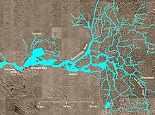
 Map Of The Stockton Deep Water Ship Channel | |
| Location | Sacramento County, San Joaquin County |
| Country | United States |
| Specifications | |
| Length | 41 miles (66 km) |
| Geography | |
| Start point | San Joaquin River |
| End point | Port of Stockton |


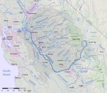
Stockton Deepwater Shipping Channel also called the Baldwin-Stockton Deepwater Shipping Channel or Stockton Deep Water Channel is a manmade deepwater water channel that runs from Suisun Bay and the Sacramento River - Sacramento Deep Water Ship Channel to the Port of Stockton and the Stockton Channel in California. The Stockton Ship Channel is 41 mi (66 km) long and about 37 ft (11 m) deep, allowing up to Panama Canal size ocean ships access to the Port of Stockton at the City of Stockton. The Stockton Deepwater Shipping Channel is part of the vast Sacramento–San Joaquin River Delta that has a connection to the Pacific Ocean. Stockton Deepwater Shipping Channel is also called the lower San Joaquin River.[1]