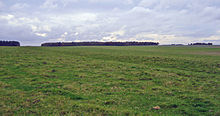
 The southern ditch and bank of the Cursus. It runs west to the gap in the trees. | |
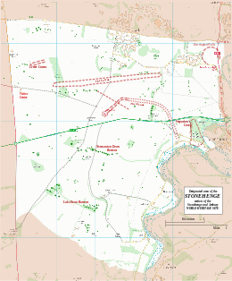
Map showing the Cursus within the Stonehenge section of the Stonehenge and Avebury World Heritage Site | |
| Alternative name | Greater Cursus and Lesser Cursus |
|---|---|
| Location | Wiltshire |
| Region | Salisbury Plain |
| Coordinates | 51°11′10″N 1°49′34″W / 51.186°N 1.826°W |
| Type | Cursus |
| Length | 2.76 kilometres (1.71 mi) |
| History | |
| Founded | 4th millennium BCE |
| Periods | Neolithic |
| Site notes | |
| Excavation dates | 1947, 2007 |
| Archaeologists | John FS Stone, Stonehenge Riverside Project |
| Condition | Excellent |
| Public access | Yes |
| Website | National Trust |
| Designated | 1986[1] |
| Reference no. | 373 |
| Designated | 1952 |
| Reference no. | 1009132[2] |
The Stonehenge Cursus (sometimes known as the Greater Cursus) is a large Neolithic cursus monument on Salisbury plain, near to Stonehenge in Wiltshire, England. It is roughly 3 kilometres (1.9 mi) long and between 100 metres (330 ft) and 150 metres (490 ft) wide. Excavations in 2007 dated the construction of the earthwork to between 3630 and 3375 BCE,[3] several hundred years before the earliest phase of Stonehenge in 3000 BC. The cursus, along with adjacent barrows and the nearby 'Lesser Cursus' are part of the National Trust's Stonehenge Landscape property, and is within the Stonehenge and Avebury World Heritage Site.
- ^ Centre, UNESCO World Heritage. "Stonehenge, Avebury and Associated Sites". whc.unesco.org.
- ^ Historic England. "The Cursus, two round barrows situated within its western end, and a long barrow situated at its eastern end (1009132)". National Heritage List for England. Retrieved 15 January 2015.
- ^ "Stonehenge Riverside Project: 2007 Excavations". shef.ac.uk. Archived from the original on 24 December 2008.
