| Strait of Gibraltar | |
|---|---|
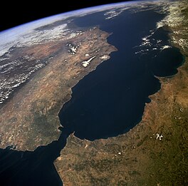
 The Strait of Gibraltar as seen from space. The Iberian Peninsula is on the left and North Africa is on the right. | |
| Location | Atlantic Ocean – Mediterranean Sea |
| Coordinates | 35°57′N 5°30′W / 35.950°N 5.500°W |
| Type | Strait |
| Basin countries | |
| Min. width | 14.2 km (8.8 mi) |
| Max. depth | 900 m (2,953 ft) |
The Strait of Gibraltar[1] is a narrow strait that connects the Atlantic Ocean to the Mediterranean Sea and separates Europe from Africa. The two continents are separated by 7.7 nautical miles (14.2 kilometers, 8.9 miles) at its narrowest point.[2] Ferries cross between the two continents every day in as little as 35 minutes. The Strait's depth ranges between 300 and 900 metres (980 and 2,950 feet; 160 and 490 fathoms).[3]
The strait lies in the territorial waters of Morocco, Spain, and the British overseas territory of Gibraltar. Under the United Nations Convention on the Law of the Sea, foreign vessels and aircraft have the freedom of navigation and overflight to cross the strait of Gibraltar in case of continuous transit.
- ^ (Arabic: مضيق جبل طارق, romanized: Maḍīq Jabal Ṭāriq; Spanish: Estrecho de Gibraltar, Archaic: Pillars of Hercules)
- ^ "Strait of Gibraltar". NASA. Retrieved 27 August 2024.
- ^ See Robinson, Allan Richard and Paola Malanotte-Rizzoli, Ocean Processes in Climate Dynamics: Global and Mediterranean Examples. Springer, 1994, p. 307, ISBN 0-7923-2624-5.
