Strathmere, New Jersey | |
|---|---|
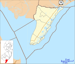
 Map of Strathmere highlighted within Cape May County. Right: Location of Cape May County in New Jersey. | |
Location in Cape May County Location in New Jersey | |
| Coordinates: 39°11′46″N 74°39′34″W / 39.19614°N 74.659412°W | |
| Country | |
| State | |
| County | Cape May |
| Township | Upper |
| Area | |
| • Total | 0.76 sq mi (1.96 km2) |
| • Land | 0.53 sq mi (1.36 km2) |
| • Water | 0.23 sq mi (0.60 km2) 21.29% |
| Elevation | 3 ft (1 m) |
| Population | |
| • Total | 137 |
| • Density | 258.5/sq mi (99.8/km2) |
| Time zone | UTC−05:00 (Eastern (EST)) |
| • Summer (DST) | UTC−04:00 (Eastern (EDT)) |
| ZIP Code | 08248[4] |
| Area code | 609 |
| FIPS code | 34-71250[5][6] |
| GNIS feature ID | 02390365[7] |
Strathmere is an unincorporated community and census-designated place (CDP)[8] located within Upper Township in Cape May County, in the U.S. state of New Jersey.[9][10] As of the 2020 United States census, the CDP's population was 137,[3] a decrease of 21 (−13.3%) from the 158 counted at the 2010 U.S. census,[11] which reflected a decrease of 17 (−9.7%) from the 175 enumerated at the 2000 census.[12]
With its beaches in the Strathmere section, Upper Township is one of five municipalities in the state that offer free public access to oceanfront beaches monitored by lifeguards, joining Atlantic City, North Wildwood, Wildwood, and Wildwood Crest.[13]
- ^ "ArcGIS REST Services Directory". United States Census Bureau. Retrieved October 11, 2022.
- ^ U.S. Geological Survey Geographic Names Information System: Strathmere Census Designated Place, Geographic Names Information System. Accessed October 19, 2012.
- ^ a b Cite error: The named reference
Census2020was invoked but never defined (see the help page). - ^ Look Up a ZIP Code for Strathmere, NJ, United States Postal Service. Accessed October 19, 2012.
- ^ U.S. Census website, United States Census Bureau. Accessed September 4, 2014.
- ^ Geographic Codes Lookup for New Jersey, Missouri Census Data Center. Accessed June 9, 2023.
- ^ US Board on Geographic Names, United States Geological Survey. Accessed September 4, 2014.
- ^ State of New Jersey Census Designated Places – BVP20 – Data as of January 1, 2020, United States Census Bureau. Accessed February 1, 2023.
- ^ New Jersey: 2010 – Population and Housing Unit Counts – 2010 Census of Population and Housing (CPH-2-32), United States Census Bureau, August 2012. Accessed October 19, 2012.
- ^ Locality Search, State of New Jersey. Accessed April 19, 2015.
- ^ DP-1 – Profile of General Population and Housing Characteristics: 2010 Demographic Profile Data for Strathmere CDP, New Jersey Archived 2020-02-12 at archive.today, United States Census Bureau. Accessed October 19, 2012.
- ^ Cite error: The named reference
Census2000was invoked but never defined (see the help page). - ^ Spoto, MaryAnn. "Surfers fighting to save dwindling free beaches", NJ Advance Media for NJ.com, May 20, 2015. Accessed October 30, 2015. "New Jersey has five free guarded ocean beaches – Atlantic City, Wildwood, North Wildwood, Wildwood Crest and the Strathmere section of Upper Township."


