Strip District | |
|---|---|
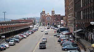
 A view of Smallman Street in 2011 | |
 | |
| Coordinates: 40°27′00″N 79°59′06″W / 40.450°N 79.985°W | |
| Country | United States |
| State | Pennsylvania |
| County | Allegheny County |
| City | Pittsburgh |
| Area | |
| • Total | 0.740 sq mi (1.92 km2) |
| • Land | 0.614 sq mi (1.59 km2) |
| • Water | 0.126 sq mi (0.33 km2) |
| Population (2020)[2] | |
| • Total | 1,845 |
| • Density | 2,500/sq mi (960/km2) |
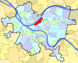
The Strip District is a neighborhood in Pittsburgh, Pennsylvania, United States. It is a one-half square mile area of land northeast of the central business district bordered to the north by the Allegheny River and to the south by portions of the Hill District. The Strip District runs between 11th and 33rd Streets and includes four main thoroughfares—Railroad Street/Waterfront Place, Smallman Street, Penn Avenue, and Liberty Avenue—as well as various side streets.
A warehouse district that was once home to many mills and factories, today the Strip District is a destination for groceries, restaurants, bars, and art. Recently, it has become home to dozens of tech and robotics companies as well as a rapidly growing residential population.[3]
- ^ "PGHSNAP 2010 Raw Census Data by Neighborhood". PGHSNAP Utility. Pittsburgh Department of City Planning. 2012. Retrieved May 24, 2024.
- ^ Census Tract 203; Allegheny County; Pennsylvania Archived 24 May 2024 at the Wayback Machine
- ^ O'Toole, Bill (April 11, 2019). "The Strip District is booming. Can local infrastructure keep up?". NEXTpittsburgh. Retrieved September 13, 2020.