| SUGARLOAF | |
|---|---|
 Sugarloaf Logo | |
| Location | Carrabassett Valley, Franklin County, Maine |
| Nearest major city | Farmington |
| Coordinates | 45°01′53″N 70°18′47″W / 45.03139°N 70.31306°W |
| Status | Operating |
| Owner | Boyne Resorts |
| Vertical | 2,820 feet (860 m) |
| Top elevation | 4,237 feet (1,291 m) |
| Base elevation | 1,417 feet (432 m) |
| Skiable area | 1,360 acres (550 ha) |
| Trails | 176 |
| Longest run | 3.5 miles (5.6 km) |
| Lift system | 15 |
| Lift capacity | 25,388 skiers per hour |
| Terrain parks | 3 (+ Superpipe) |
| Snowfall | 200 inches (510 cm) (10 year average)[1] |
| Snowmaking | Yes, 95% |
| Night skiing | No |
| Website | Sugarloaf.com |
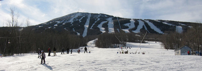
Sugarloaf (formerly Sugarloaf/USA) is a ski area and resort located on Sugarloaf Mountain in Carrabassett Valley, western Maine. It is the second largest ski resort east of the Mississippi in terms of skiable area (1,240 acres or 500 ha after Killington's 1,509 acres or 611 ha)[1][2] and snowmaking percentage (95%); its continuous vertical drop of 2,820 feet (860 m) is the second longest in New England (after Killington's 3,050 feet (930 m)).[1][2] Sugarloaf recorded a total of 352,000 skier visits in the 2005–2006 season, ranking it second among Maine resorts and 11th in New England.[3]
At 4,237 feet (1291 m) Sugarloaf Mountain is third in elevation to Maine's highest peak, Mount Katahdin. It is second to Hamlin Peak, an adjacent spur of Mt Katahdin. It has the highest peak elevation of any ski resort in New England (just 8 feet above Killington's 4,229 foot summit) and offers the only lift-serviced above-treeline skiing in the Northeast.[1] The Appalachian Trail crosses within 0.6 miles (0.97 km) of Sugarloaf's peak and the summit offers 360-degree views of Maine's western mountains and New Hampshire's White Mountains.[4]
As of October 2022, there were over 60 miles (97 km) of marked trails and a total of 651 acres (263 ha) of developed trails. There were 1,400 acres (570 ha) of skiable area boundary to boundary. The thirteen chairlifts have the capacity to carry 21,810 skiers per hour. There are also 162 marked trails and glades, most of which are named after logging terms in a tribute to Maine's logging history. Trails include thirty-four rated as green circle (25%), forty-four blue square (32%), thirty-nine black diamond (28%), and twenty-one rated double black diamond (15%). There are also thirty named glades, and three terrain parks. Lifts include two high-speed quads, three fixed-grip quads, one triple, five doubles, one T-bar, and one carpet surface lift. The Sugarloaf season runs from mid-November through early May.[5]

- ^ a b c d "Sugarloaf Stats". Sugarloaf. Archived from the original on 14 November 2018. Retrieved 14 November 2018.
- ^ a b "Mountain Stats". Killington Ski Resort. Archived from the original on 2 March 2016. Retrieved 25 February 2016.
- ^ "CNL Owns, Boyne USA to Operate, Sugarloaf and Sunday River". Ski Area Management. 8 August 2007. Retrieved 14 November 2018.
- ^ National Park Service, comp. "Appalachian Trail." Map.
- ^ "The Mountain". Sugarloaf. Archived from the original on 7 August 2020. Retrieved 7 October 2020.