Sujawal District
| |
|---|---|
 Mangrove plantation near Shahbandar | |
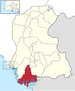
 Map of Sindh with Sujawal District highlighted | |
| Country | |
| Province | |
| Division | Hyderabad |
| Established | 12 October 2013 |
| Headquarters | Sujawal |
| Government | |
| • Type | District Administration |
| • Deputy Commissioner | N/A |
| • District Police Officer | N/A |
| • District Health Officer | N/A |
| Area | |
| • District of Sindh | 8,785 km2 (3,392 sq mi) |
| Population | |
| • District of Sindh | 839,292 |
| • Density | 96/km2 (250/sq mi) |
| • Urban | 88,847 |
| • Rural | 750,445 |
| Time zone | UTC+5 (PST) |
| Number of Tehsils | 4 |
| Website | borsindh.gov.pk/ |
Sujawal District (Sindhi: سجاول ضلعو, Urdu: ضلع سجاول) is a district of the Sindh province of Pakistan.[2] It is located at 24°36'23" North and 68°4'19" East[3] and is bordered in the northwest by the Indus River, which separates it from Thatta District. The district has an area of 7335 km2.
- ^ Cite error: The named reference
2023censuswas invoked but never defined (see the help page). - ^ "Thatta Split to Make Sujawal 28th district of Sindh". Dawn News. Retrieved 25 October 2013.
- ^ "Location of Sujawal - Falling Rain Genomics". Falling Rain Genomics. Retrieved 25 October 2013.