| Location | |
|---|---|
| OS grid reference | HX621244 |
| Coordinates | 59°05′N 4°25′W / 59.08°N 4.41°W |
| Physical geography | |
| Island group | North Atlantic |
| Area | 16 ha (40 acres) |
| Highest elevation | 12 m (39 ft) |
| Administration | |
| Council area | Orkney |
| Country | Scotland |
| Sovereign state | United Kingdom |
| Demographics | |
| Population | 0 |
| References | [1][2][3] |
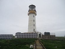
| Sule Skerry Lighthouse | |
 | |
| Coordinates | 59°05′05″N 4°24′26″W / 59.084713°N 4.407325°W |
| Constructed | 1895 |
| Built by | David Alan Stevenson, Charles Alexander Stevenson |
| Construction | masonry tower |
| Automated | 1982 |
| Height | 27 m (89 ft) |
| Shape | cylindrical tower with balcony and lantern |
| Markings | white tower, black lantern, ochre trim |
| Power source | solar power |
| Operator | Northern Lighthouse Board[4][5] |
| Heritage | category A listed building |
| Focal height | 34 m (112 ft) |
| Lens | "hyperradiant" Fresnel lens |
| Range | 21 nmi (39 km) |
| Characteristic | Fl (2) W 15 s |
Sule Skerry is a remote skerry in the North Atlantic off the north coast of Scotland.
- ^ National Records of Scotland (15 August 2013). "Appendix 2: Population and households on Scotland's Inhabited Islands" (PDF). Statistical Bulletin: 2011 Census: First Results on Population and Household Estimates for Scotland Release 1C (Part Two) (PDF) (Report). SG/2013/126. Retrieved 14 August 2020.
- ^ Haswell-Smith, Hamish (2004). The Scottish Islands. Edinburgh: Canongate. ISBN 978-1-84195-454-7.
- ^ Ordnance Survey: Landranger map sheet 6 Orkney (Mainland) (Map). Ordnance Survey. 2014. ISBN 9780319228128.
- ^ Rowlett, Russ. "Lighthouses of Scotland: Orkney". The Lighthouse Directory. University of North Carolina at Chapel Hill. Retrieved 12 May 2016.
- ^ Sule Skerry Northern Lighthouse Board. Retrieved 12 May 2016
